Plan Your Trip Road Cycling around Whistler Renowned for mountain biking, Whistler also boasts plenty of riding for road enthusiasts Go the distance on smooth, recently upgraded highway routes and challenge yourself with mountain climbs Base yourself in Whistler and explore the area over several days - suggested routes below Participate in or watch exciting events like the RBC GranFondo Whistler Olympic Park Pemberton Whistler Duffey Lake Squamish Tips & More Suggested Route: Olympic Park A beautiful ride up a winding road with excellent views of the Callaghan Valley, site of the Olympic Ski Jumping and Nordic events. See Ride Details Accumulated Elevation Gain: 520 m Length: 27 km Start: Village Gate Blvd. at Hwy 99 Finish: Biathlon Stadium Print ride details Suggested Route: Whistler Village to Pemberton A long-time locals favourite, this ride is mostly downhill to Pemberton so be sure to save some energy for the ride back to Whistler. See Ride Details Accumulated Elevation Gain: 245 m (Accumulated Elevation loss: 645 m) Length: 32 km Start: Village Gate Blvd. at Hwy 99 Finish: Pemberton Petro Canada Print ride details Suggested Route: Pemberton Meadows Starting in Pemberton, an easy 50km loop can be made by riding up to the end of Pemberton Meadows and back. This ride is generally sees little vehicle traffic and takes you past the picturesque farms of Pemberton Valley. The views of Mount Currie on the return leg are stunning. See Ride Details Accumulated Elevation Gain: 129 m Length: 30 km Start: Pemberton Petro Canada Finish: Bridge over Lillooet River on approach to Hurley Road Print ride details Suggested Route: Tour de Whistler Another local favourite with some excellent hill-climbing. This ride does a loop of the valley, taking in nine climbs of significance. From the Village head north to Emerald, then back through Alpine Meadows to Alta Lake road. Ride south past Rainbow Park and up to the top of Stonebridge. Continue south on Alta Lake road, crossing Hwy99 to the climb up Kadenwood. From here the ride heads back north to the Village, taking in the climbs of Bear Ridge, Taluswood, Panorama Ridge, Base 2, and up Painted Cliff road. See Ride Details Accumulated Elevation Gain: 1300 m Length: 52 km Start: Village Gate Blvd. at Hwy 99 Finish: Village Gate Blvd. at Hwy 99 Print ride details Suggested Route: Duffey Lake Road The mother of all climbs! From Lilloet Lake to the Joffre col, this ride climbs 1,000m in 15km. Depending on your fitness level, you can start in either Whistler or Pemberton or continue all the way to Lillooet. See Ride Details Accumulated Elevation Gain: 1118 m Length: 30 km Start: Pemberton Petro Canada Finish: Joffre Lakes Parking Lot Print ride details Suggested Route: Whistler to Squamish Although this section of the highway sees heavy traffic, recent upgrades have created a wide shoulder on which to ride. Even though the route is mostly downhill, be aware of the strong wind that often blows up the valley – it can make the final descent into Squamish harder than it seems! See Ride Details Accumulated Elevation Gain: 600 m (Accumulated Elevation loss: 1290 m) Length: 51 km Start: Function Junction (intersection of Highway 99 and Alpha Lake Road) Finish: Downtown Squamish Print ride details Local Tips and Resources Visitors are welcome to sign up for weekly group rides with the Whistler Cycling Club. Learn more about road cycling in the Sea to Sky Corridor including routes and safety tips – view brochure
Suggested Route: Olympic Park A beautiful ride up a winding road with excellent views of the Callaghan Valley, site of the Olympic Ski Jumping and Nordic events. See Ride Details Accumulated Elevation Gain: 520 m Length: 27 km Start: Village Gate Blvd. at Hwy 99 Finish: Biathlon Stadium Print ride details
Suggested Route: Whistler Village to Pemberton A long-time locals favourite, this ride is mostly downhill to Pemberton so be sure to save some energy for the ride back to Whistler. See Ride Details Accumulated Elevation Gain: 245 m (Accumulated Elevation loss: 645 m) Length: 32 km Start: Village Gate Blvd. at Hwy 99 Finish: Pemberton Petro Canada Print ride details Suggested Route: Pemberton Meadows Starting in Pemberton, an easy 50km loop can be made by riding up to the end of Pemberton Meadows and back. This ride is generally sees little vehicle traffic and takes you past the picturesque farms of Pemberton Valley. The views of Mount Currie on the return leg are stunning. See Ride Details Accumulated Elevation Gain: 129 m Length: 30 km Start: Pemberton Petro Canada Finish: Bridge over Lillooet River on approach to Hurley Road Print ride details
Suggested Route: Tour de Whistler Another local favourite with some excellent hill-climbing. This ride does a loop of the valley, taking in nine climbs of significance. From the Village head north to Emerald, then back through Alpine Meadows to Alta Lake road. Ride south past Rainbow Park and up to the top of Stonebridge. Continue south on Alta Lake road, crossing Hwy99 to the climb up Kadenwood. From here the ride heads back north to the Village, taking in the climbs of Bear Ridge, Taluswood, Panorama Ridge, Base 2, and up Painted Cliff road. See Ride Details Accumulated Elevation Gain: 1300 m Length: 52 km Start: Village Gate Blvd. at Hwy 99 Finish: Village Gate Blvd. at Hwy 99 Print ride details
Suggested Route: Duffey Lake Road The mother of all climbs! From Lilloet Lake to the Joffre col, this ride climbs 1,000m in 15km. Depending on your fitness level, you can start in either Whistler or Pemberton or continue all the way to Lillooet. See Ride Details Accumulated Elevation Gain: 1118 m Length: 30 km Start: Pemberton Petro Canada Finish: Joffre Lakes Parking Lot Print ride details
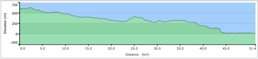
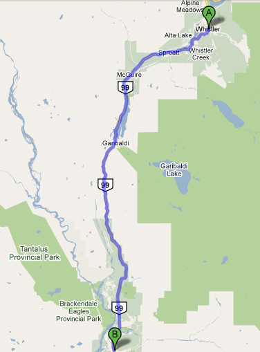
Suggested Route: Whistler to Squamish Although this section of the highway sees heavy traffic, recent upgrades have created a wide shoulder on which to ride. Even though the route is mostly downhill, be aware of the strong wind that often blows up the valley – it can make the final descent into Squamish harder than it seems! See Ride Details Accumulated Elevation Gain: 600 m (Accumulated Elevation loss: 1290 m) Length: 51 km Start: Function Junction (intersection of Highway 99 and Alpha Lake Road) Finish: Downtown Squamish Print ride details
Local Tips and Resources Visitors are welcome to sign up for weekly group rides with the Whistler Cycling Club. Learn more about road cycling in the Sea to Sky Corridor including routes and safety tips – view brochure